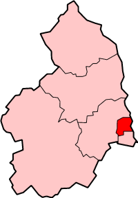
Wansbeck District
This article includes a list of references, related reading, or external links, but its sources remain unclear because it lacks inline citations. (November 2019) |
Wansbeck District | |
|---|---|
Former District | |
 Shown within Northumberland | |
| Coordinates: 55°10′08″N 1°34′26″W / 55.169°N 1.574°W | |
| Sovereign state | United Kingdom |
| Constituent country | England |
| Region | North East England |
| Administrative county | Northumberland |
| Founded | 1 April 1974 |
| Abolished | 1 April 2009 |
| Admin. HQ | Ashington |
| Government | |
| • Type | Wansbeck District Council |
| • Leadership: | Leader & Cabinet |
| Time zone | UTC+0 (Greenwich Mean Time) |
| • Summer (DST) | UTC+1 (British Summer Time) |
| ONS code | 35UG |
| Ethnicity | 99.0% White |
| Website | wansbeck.gov.uk |
Wansbeck was a local government district in south-east Northumberland, England. Its main population centres were Ashington, Bedlington and Newbiggin-by-the-Sea.
The area which was bounded by the district is mostly urban, on the North Sea coast north of the Tyneside conurbation. It bordered Blyth Valley district to the south, the border being the River Blyth. It was formed on 1 April 1974, under the Local Government Act 1972, by the merger of the urban districts of Ashington, Bedlingtonshire and Newbiggin-by-the-Sea. It is named after the River Wansbeck.
The district council was abolished as part of the 2009 structural changes to local government in England effective from 1 April 2009 with responsibilities being transferred to Northumberland County Council, a unitary authority.
Notable people
[edit]- Sean Taylor, professional footballer
See also
[edit]External links
[edit]- Statistics about the Wansbeck district from the Office for National Statistics Census 2001


