Constância
Appearance
Constância | |
|---|---|
 | |
 | |
| Coordinates: 39°21′N 8°29′W / 39.350°N 8.483°W | |
| Country | |
| Region | Oeste e Vale do Tejo |
| Intermunic. comm. | Médio Tejo |
| District | Santarém |
| Parishes | 3 |
| Government | |
| • President | António Mendes (CDU) |
| Area | |
| • Total | 80.37 km2 (31.03 sq mi) |
| Population (2011) | |
| • Total | 4,056 |
| • Density | 50/km2 (130/sq mi) |
| Time zone | UTC±00:00 (WET) |
| • Summer (DST) | UTC+01:00 (WEST) |
| Local holiday | Easter Monday (date varies) |
| Website | http://www.cm-constancia.pt |
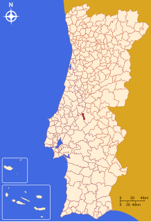
Constância (Portuguese pronunciation: [kõʃˈtɐ̃siɐ] ) is a municipality in Santarém District in Portugal. The population in 2011 was 4,056,[1] in an area of 80.37 km².[2]
Conquered from the Moors in 1150, it was given the status of 'town' in 1571 through a charter from King Sebastian. Portuguese national poet Luís de Camões lived in exile there between 1548 and 1550. In 1809, the English army met in Constância before marching on Spain, on their way to the Battle of Talavera, where Wellington defeated the French.[citation needed]
Parishes
[edit]Administratively, the municipality is divided into 3 civil parishes (freguesias):[3]
Notable people
[edit]- Tomaz Vieira da Cruz (1900 in Constância – 1960 in Lisbon) a poet, musician and journalist.
References
[edit]- ^ Instituto Nacional de Estatística
- ^ "Áreas das freguesias, concelhos, distritos e país". Archived from the original on 2018-11-05. Retrieved 2018-11-05.
- ^ Diário da República. "Law nr. 11-A/2013, page 552 42" (pdf) (in Portuguese). Retrieved 21 July 2014.
External links
[edit]- Town Hall official website Archived 2015-11-25 at the Wayback Machine
- Photos from Constância


